Your wildfire map is not a mitigation plan.
RF1 turns mapped hazard, local vegetation, ember-entry points, Zone 0, roof edges, decks, fences, and insurance documentation into a short fix order for your specific home.
Or book a free RF1 walkthrough when you are ready for a field assessment.
The useful answer is not just whether the neighborhood is risky. It is where the house is vulnerable.
Get the three decisions right before you spend.
The wrong order wastes budget. The right order starts with how embers reach the home, what feeds that exposure, and what proof needs to be saved.
Is my home actually exposed?
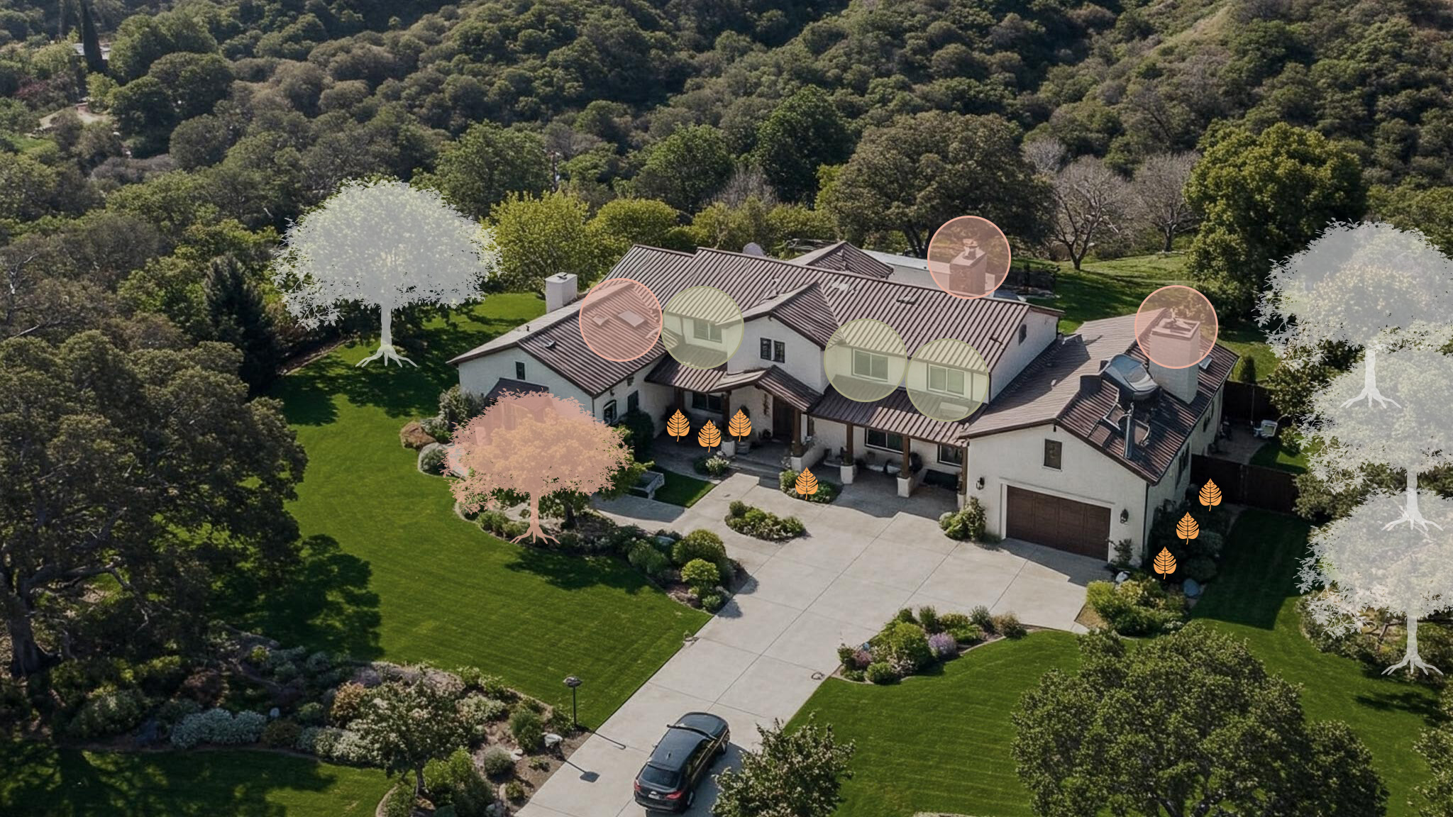
A map can show the neighborhood hazard, but the real exposure is usually at the structure: vents, roof edges, decks, fences, dry debris, slope, and nearby vegetation.
Where should I spend first?
RF1 prioritizes the work that changes risk fastest. That usually means ember-entry points first, then Zone 0 and the connected fuel paths closest to the home.
Will this help with insurance conversations?
Mitigation is easier to explain when the work is documented. RF1 organizes photos, materials, and next steps into notes a homeowner can share clearly.
Why not just use a generic checklist?
A hillside rebuild, older cottage, canyon parcel, and dense neighborhood home do not need the same first move. The assessment matches the plan to the property.
RF1 starts where small failures become expensive ones.
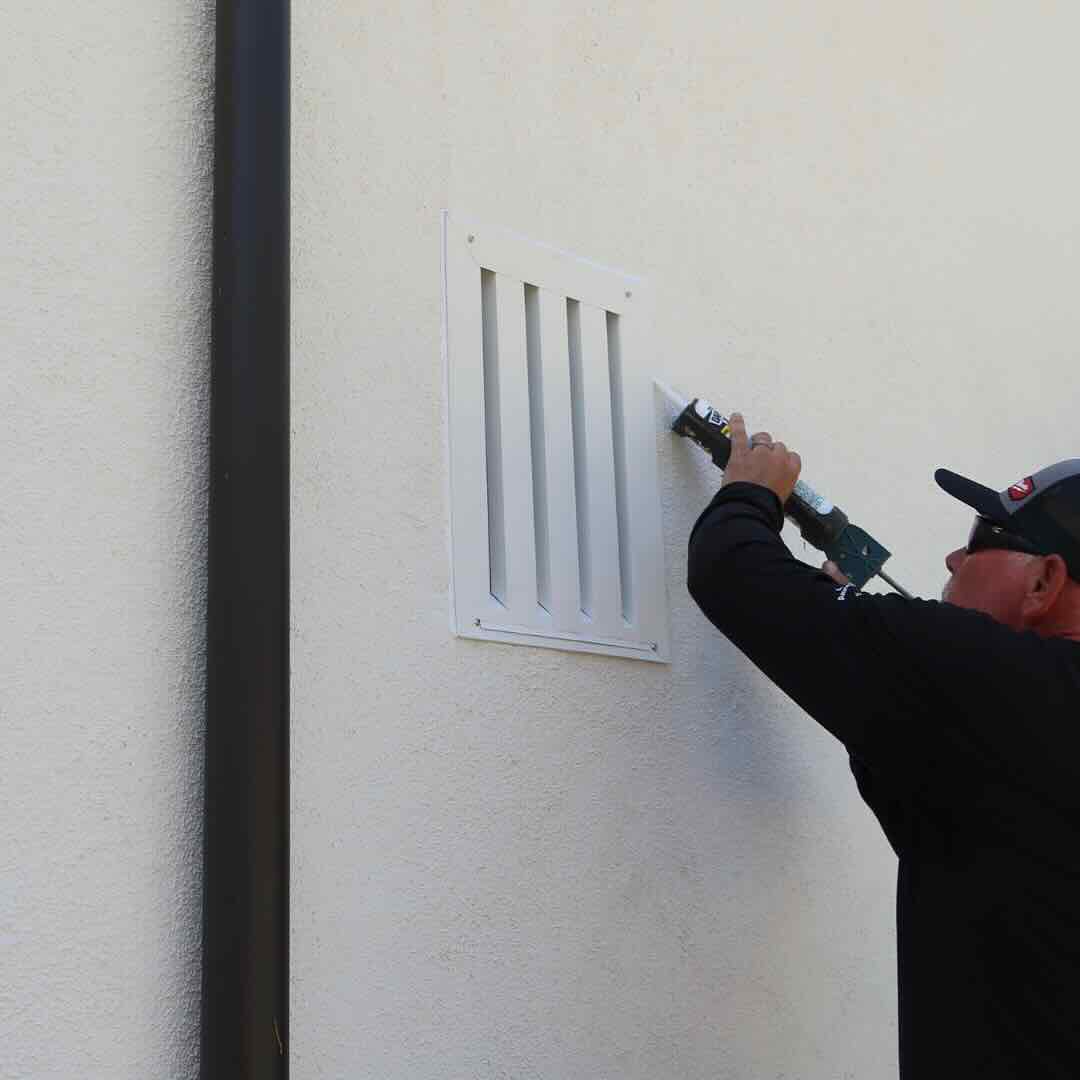
Vents and openings
Find the openings embers can use before flames reach the house.
Zone 0 and attached fuel paths
Remove or separate the materials that can carry fire to walls, windows, doors, and decks.
Roof edges, gutters, decks, and fences
Identify the debris traps and attachments where small ignition points become structure problems.
Documentation
Leave with a practical record of what was checked, what matters first, and what to fix next.
Local risk changes fast. Your page should too.
A foothill block, canyon road, coastal slope, and estate parcel can need different first moves. Use the local page to see how terrain, vegetation, housing patterns, and authority guidance change the assessment.
Service areas
- Altadena
San Gabriel Mountain foothills
- Sierra Madre
Foothill neighborhoods below the Angeles National Forest
- Pacific Palisades
Santa Monica Mountains, coastal bluffs, and canyon neighborhoods
- Calabasas
Las Virgenes, Malibu Creek, and Santa Monica Mountains WUI neighborhoods
- Thousand Oaks
Conejo Valley, Wildwood, Lang Ranch, and open-space edge neighborhoods
- Carpinteria
Carpinteria foothills, Toro Canyon, coastal ranches, and canyon-edge homes
- Hollywood Hills
Laurel Canyon, Nichols Canyon, Beachwood Canyon, Mulholland, and hillside streets
- Pasadena
Arroyo, foothill, and canyon-adjacent neighborhoods
- Malibu
Coastal canyons, ridgelines, and WUI neighborhoods
- Brentwood
Mandeville Canyon, Kenter Canyon, and westside hillside neighborhoods
- Montecito
Santa Barbara frontcountry and foothill neighborhoods
- Santa Barbara
Riviera, Mission Canyon, foothills, and coastal frontcountry neighborhoods
- La Crescenta
Crescenta Valley, Verdugo Mountains, and San Gabriel foothill neighborhoods
- La Cañada Flintridge
San Gabriel Mountain foothills
- Topanga
Santa Monica Mountains canyon neighborhoods
- Bel Air
Stone Canyon, Sepulveda Pass, and Santa Monica Mountain hillside homes
- Agoura Hills
Santa Monica Mountains, Chesebro Canyon, and open-space edge neighborhoods
- Ojai
Ojai Valley, Nordhoff Ridge, rural roads, and canyon-edge neighborhoods
- Burbank Hills
Verdugo Mountains, Wildwood Canyon, Stough Canyon, and hillside streets
Guidance tells you what matters. The assessment tells you what to do next.
CAL FIRE maps, city programs, county fire rules, brush clearance, defensible space, and insurance requests can point in the right direction. RF1 translates that into the practical sequence at the house.