La Cañada Flintridge wildfire risk mitigation, home hardening, and assessment
RF1 helps La Cañada Flintridge homeowners understand local wildfire exposure, prioritize defensible space and home-hardening work, and document mitigation clearly for insurance conversations.
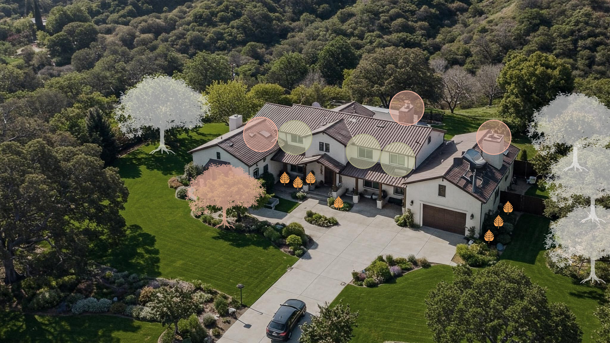
Large lots still need a structure-first plan: vents, rooflines, decks, trees, and Zone 0.
Start with the risks you can actually fix
Vents firstClose ember entry points before yard work gets expensive.
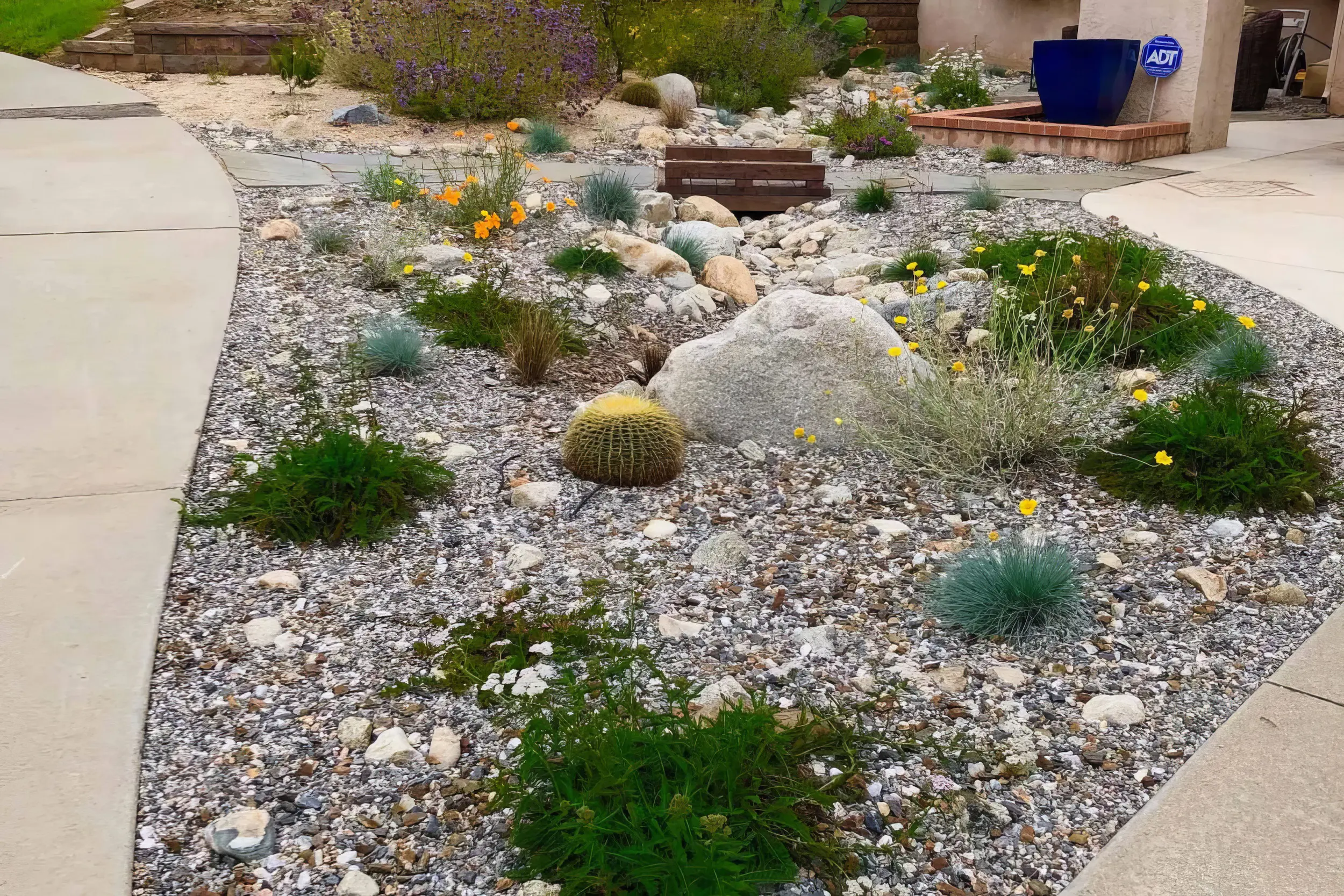
Zone 0 nextClean the first 5 feet and break fuel paths to the house.
Proof mattersLeave with photos and a short, ranked mitigation plan.
Local risk context
The map tells you the neighborhood. RF1 tells you what to fix at the house.
La Cañada Flintridge combines steep terrain, canyon wind exposure, larger lots, mature trees, and high-value homes. The best mitigation plans start at the structure and work outward through Zone 0, rooflines, vents, decks, and slope vegetation.
The useful answer is not “am I in a fire zone?” It is “what should I fix first?”
Start with the mapped exposure. RF1 uses the local hazard context to understand slope, canyon wind, and nearby vegetation pressure.
Then inspect the ember paths. Vents, roof edges, decks, fences, attachments, plants, and debris decide how that exposure reaches the home.
Leave with a short fix order. The assessment turns the map into a ranked plan for vents first, Zone 0 next, and documentation for insurance conversations.
CAL FIRE risk context near La Cañada Flintridge
Pan and click mapped zones to compare nearby hazard classifications.
Local fire history
Fires that shaped wildfire risk in La Cañada Flintridge
Most of La Cañada Flintridge is mapped in Very High Fire Hazard Severity Zones — among the highest hazard coverage of any city in the county. The 2009 Station Fire and the debris flows that followed showed that mitigation here has to consider both ember exposure and the slope behavior that follows a burn.
2009
Station Fire
Burned the slopes directly above La Cañada Flintridge as it became the largest fire in Los Angeles County history, with flames visible from neighborhood streets.
2010
Post-Station debris flows
Winter storms over the fresh burn scar sent debris flows into foothill neighborhoods, damaging homes and showing how fire risk and slope risk are linked here.
2025
Eaton Fire
Burned the foothill corridor just east of the city, putting the entire San Gabriel front — including La Cañada Flintridge — on alert during the January windstorm.
Local vegetation and Zone 0
The plants are not the whole problem. The path to the house is.

La Cañada Flintridge sits hard against the San Gabriel foothills, where canyon wind, slope, long driveways, and mature canopy can change the mitigation plan from one parcel to the next.
In La Cañada Flintridge, RF1 looks for the ways vegetation, fences, roof edges, gutters, and neighboring lots connect. The goal is not to strip the yard. It is to break the ember path before it reaches vents, siding, windows, decks, and the first 5 feet around the structure.
Local signals RF1 checks first
First move
Start with ember entry points like vents and roof edges, then clean up Zone 0 around the yard.
Book a Free Wildfire Risk Assessment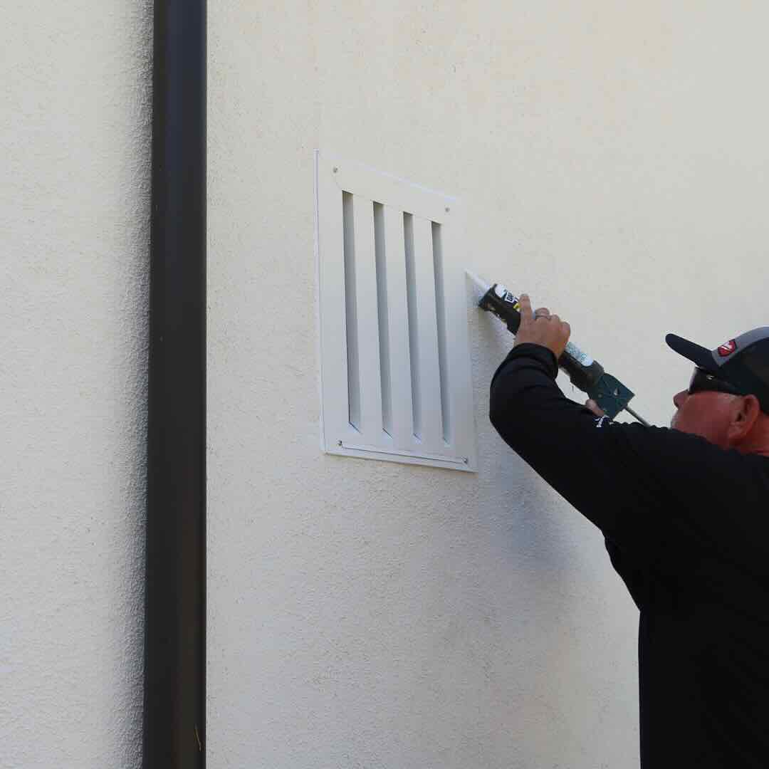
1. Protect openings
Vents, eaves, attic entries, and roof edges are where ember defense starts.
2. Clear the ember path
Then clean up the first 5 feet: mulch, dry leaves, stored items, fences, and plants touching the home.
3. Make it usable
Leave with a short priority list, not a pile of advice.
RF1 separates what to do now, what can wait, and what should be photographed for insurance conversations.
Home-specific plan
The right plan depends on the home, the slope, and the access
Homes are often larger, custom, and set into sloped or canyon-adjacent parcels. Lots may feel spacious, but long driveways, mature landscaping, and slope exposure can make access, ember defense, and vegetation spacing more complex.
RF1 adjusts the order of work to the house: vents and ember entry points first, then the vegetation and attachments that feed them.
What your RF1 assessment answers
01
Where can embers get in?
Vents, roof edges, eaves, gaps, decks, and attachments.
02
What is feeding that exposure?
Mulch, dry leaves, hedges, fences, sheds, and nearby canopy.
03
What should be fixed first?
A ranked plan with photos, materials, and insurance-ready notes.
Official resources
Official guidance, translated into a real plan
Use these resources for official fire department, city, county, and CAL FIRE guidance. RF1 can help translate the requirements into a practical property checklist and documented mitigation plan.
Homeowner questions
Common La Cañada Flintridge wildfire mitigation questions
Is all of La Cañada Flintridge in a Very High Fire Hazard Severity Zone?
Nearly all of the city carries the Very High designation, which triggers defensible space requirements, Chapter 7A construction standards for new work, and AB 38 inspection requirements when a home sells. RF1 confirms your parcel's exact designation and turns the requirements into a ranked work plan.
Why do La Cañada assessments look at drainage and slopes, not just vegetation?
Because the Station Fire's aftermath proved the point: burned slopes shed water and debris into the same canyons that funnel wind and embers. A good mitigation plan for this terrain covers ember entry points first, then evaluates how slope vegetation, retaining walls, and drainage paths interact with the structure.
Do I need a wildfire risk assessment in La Cañada Flintridge?
La Cañada Flintridge homes can have very different exposure depending on slope, vegetation, rooflines, vents, neighboring parcels, and Zone 0 conditions. A parcel-level assessment helps prioritize the work that matters first.
What does RF1 check during a La Cañada Flintridge assessment?
RF1 checks Zone 0, roof edges, gutters, vents, eaves, decks, fences, vegetation, access, and documentation needs. The goal is a prioritized mitigation plan, not a generic checklist.
Can wildfire mitigation help with insurance documentation?
Mitigation work can support insurance conversations when it is clearly documented. RF1 helps organize photos, scope, materials, and next steps so homeowners can share a concise package with their agent or carrier.
Wildfire risk assessments near La Cañada Flintridge
Get a wildfire mitigation checklist for your La Cañada Flintridge home
RF1 turns the map, vegetation, home-hardening issues, and insurance documentation into a prioritized plan you can actually use.