Agoura Hills wildfire risk mitigation, home hardening, and assessment
RF1 helps Agoura Hills homeowners understand local wildfire exposure, prioritize defensible space and home-hardening work, and document mitigation clearly for insurance conversations.
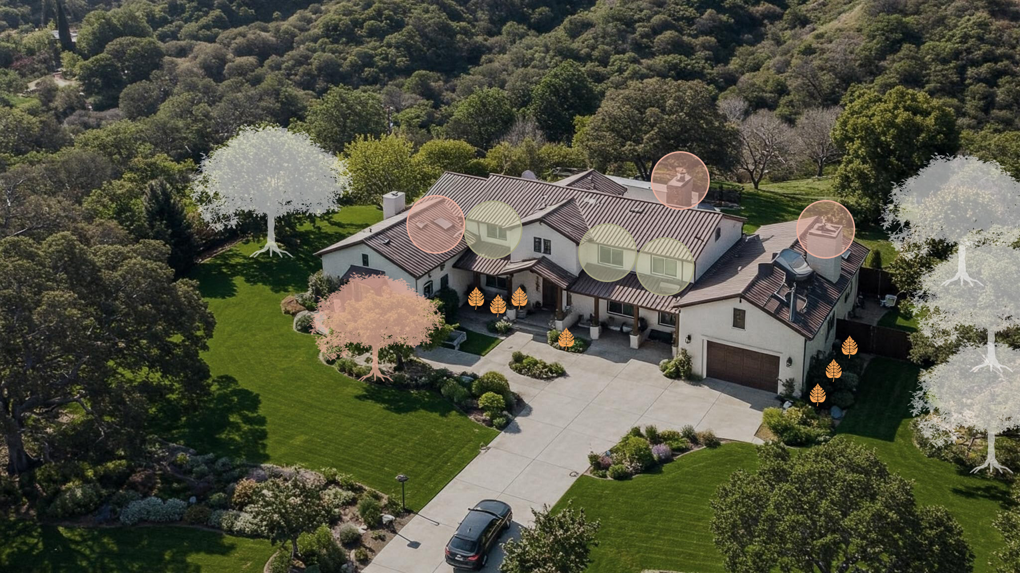
In Agoura Hills, open-space edges, canyon roads, slopes, vents, and Zone 0 all shape the fix order.
Start with the risks you can actually fix
Vents firstClose ember entry points before yard work gets expensive.
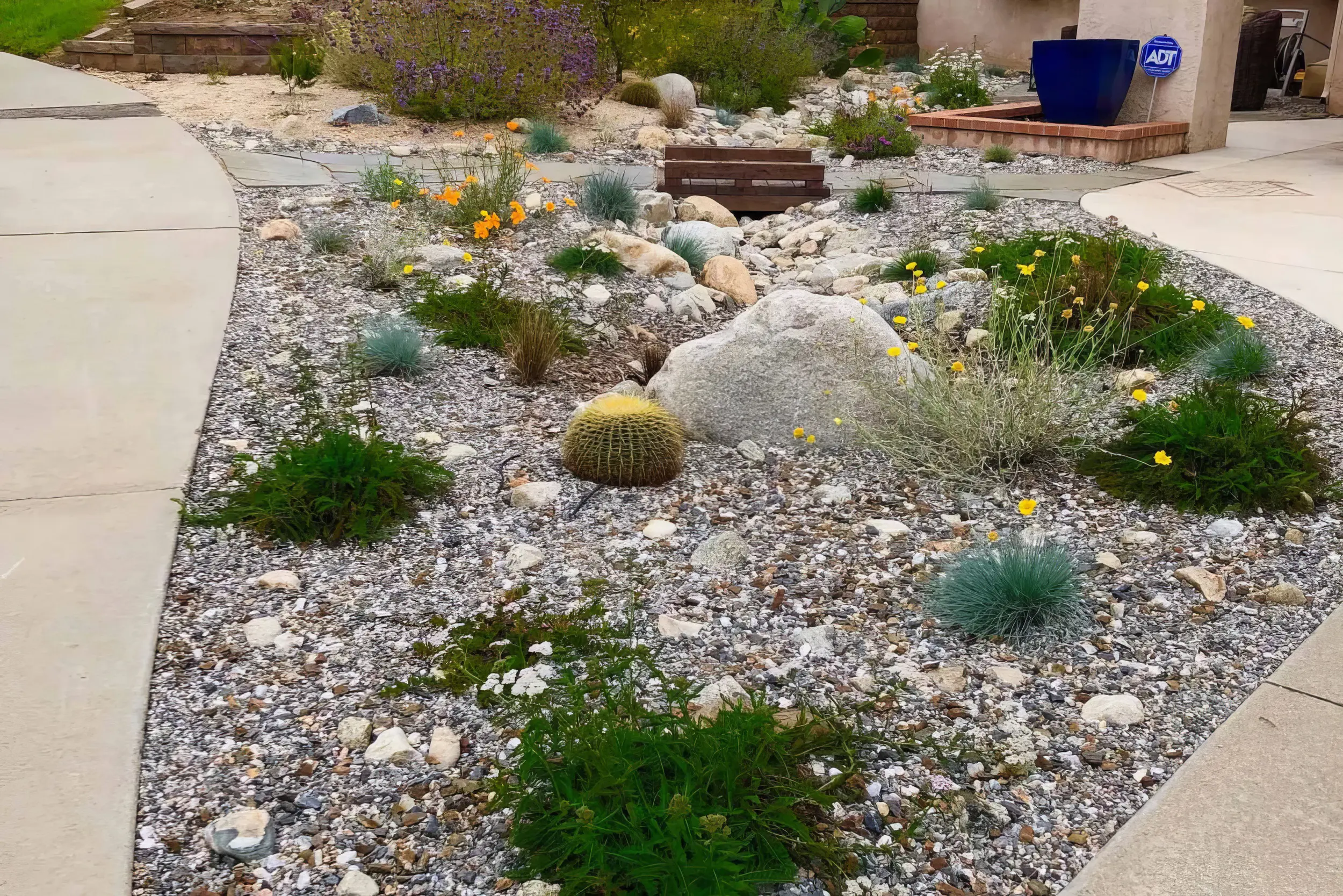
Zone 0 nextClean the first 5 feet and break fuel paths to the house.
Proof mattersLeave with photos and a short, ranked mitigation plan.
Local risk context
The map tells you the neighborhood. RF1 tells you what to fix at the house.
Agoura Hills sits where neighborhoods meet the Santa Monica Mountains, Chesebro Canyon, Palo Comado Canyon, oak woodland, chaparral, and open-space edges. A useful assessment has to connect the mapped hazard with vents, roof edges, Zone 0, decks, fences, long driveways, and nearby slope vegetation.
The useful answer is not “am I in a fire zone?” It is “what should I fix first?”
Start with the mapped exposure. RF1 uses the local hazard context to understand slope, canyon wind, and nearby vegetation pressure.
Then inspect the ember paths. Vents, roof edges, decks, fences, attachments, plants, and debris decide how that exposure reaches the home.
Leave with a short fix order. The assessment turns the map into a ranked plan for vents first, Zone 0 next, and documentation for insurance conversations.
CAL FIRE risk context near Agoura Hills
Pan and click mapped zones to compare nearby hazard classifications.
Local fire history
Fires that shaped wildfire risk in Agoura Hills
Agoura Hills is mapped largely in Very High Fire Hazard Severity Zones, with neighborhoods wrapped by Chesebro Canyon, Palo Comado Canyon, and Santa Monica Mountains open space. Woolsey demonstrated that fire here moves fast and crosses freeways; the city's Community Wildfire Protection Plan now guides the local response, and parcel-level hardening is the homeowner's share of it.
2018
Woolsey Fire
Jumped the 101 near Liberty Canyon and burned through the Agoura Hills area, forcing citywide evacuations while nearby communities lost hundreds of homes.
2025
Kenneth Fire
Burned in the Upper Las Virgenes Canyon open space east of the city during the January windstorm, prompting evacuations along the open-space edge.
Local vegetation and Zone 0
The plants are not the whole problem. The path to the house is.

Agoura Hills sits between open-space neighborhoods, canyon terrain, oak woodland, and the Santa Monica Mountains, where the plan has to start at the house and work outward.
In Agoura Hills, RF1 looks for the ways vegetation, fences, roof edges, gutters, and neighboring lots connect. The goal is not to strip the yard. It is to break the ember path before it reaches vents, siding, windows, decks, and the first 5 feet around the structure.
Local signals RF1 checks first
First move
Start with ember entry points like vents and roof edges, then clean up Zone 0 around the yard.
Book a Free Wildfire Risk Assessment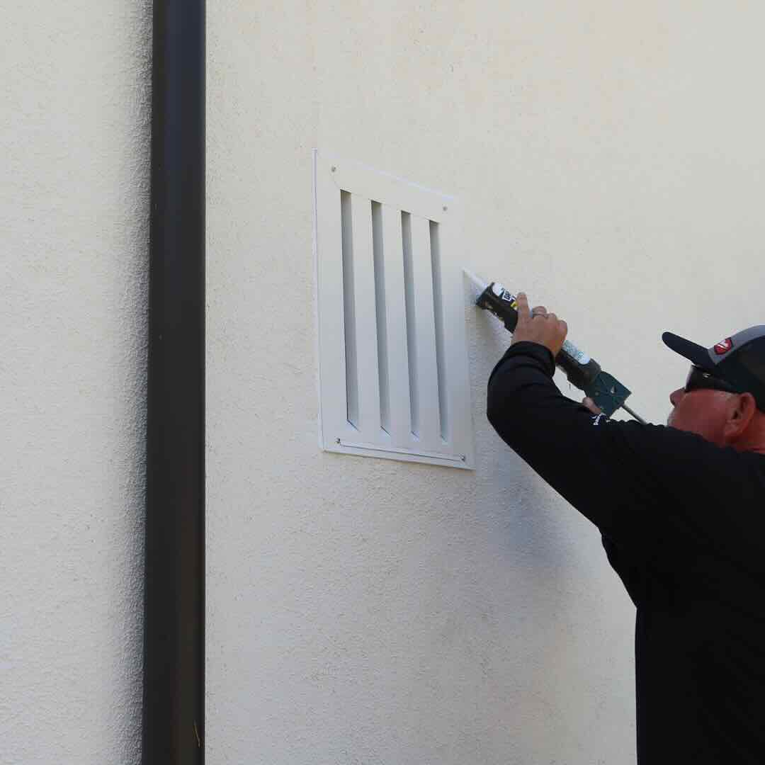
1. Protect openings
Vents, eaves, attic entries, and roof edges are where ember defense starts.
2. Clear the ember path
Then clean up the first 5 feet: mulch, dry leaves, stored items, fences, and plants touching the home.
3. Make it usable
Leave with a short priority list, not a pile of advice.
RF1 separates what to do now, what can wait, and what should be photographed for insurance conversations.
Home-specific plan
The right plan depends on the home, the slope, and the access
Agoura Hills includes older ranch-style homes, custom hillside houses, equestrian parcels, cul-de-sac neighborhoods, and homes near preserved open space. Large lots can still have close-in ember risk when vents, decks, fences, roof debris, or ornamental screening connect to the structure.
RF1 adjusts the order of work to the house: vents and ember entry points first, then the vegetation and attachments that feed them.
What your RF1 assessment answers
01
Where can embers get in?
Vents, roof edges, eaves, gaps, decks, and attachments.
02
What is feeding that exposure?
Mulch, dry leaves, hedges, fences, sheds, and nearby canopy.
03
What should be fixed first?
A ranked plan with photos, materials, and insurance-ready notes.
Official resources
Official guidance, translated into a real plan
Use these resources for official fire department, city, county, and CAL FIRE guidance. RF1 can help translate the requirements into a practical property checklist and documented mitigation plan.
Homeowner questions
Common Agoura Hills wildfire mitigation questions
Can I clear or trim the oak trees on my Agoura Hills property for fire safety?
Native oaks are protected by local ordinance, so removal generally requires a permit — but most oak-related fire risk does not require removing the tree. Clearing leaf litter, thinning ladder fuels beneath the canopy, and keeping limbs off the roofline deliver most of the benefit while keeping the oak. RF1 plans around protected trees rather than against them.
What did the Woolsey Fire change about wildfire planning in Agoura Hills?
Woolsey crossed the 101 — something many residents assumed could not happen — and the city has since adopted a Community Wildfire Protection Plan. For individual homes the lesson is that distance from open space is not protection during a wind event; ember-entry hardening at vents, roofs, and the first 5 feet is what changes outcomes.
Do I need a wildfire risk assessment in Agoura Hills?
Agoura Hills homes can have very different exposure depending on slope, vegetation, rooflines, vents, neighboring parcels, and Zone 0 conditions. A parcel-level assessment helps prioritize the work that matters first.
What does RF1 check during a Agoura Hills assessment?
RF1 checks Zone 0, roof edges, gutters, vents, eaves, decks, fences, vegetation, access, and documentation needs. The goal is a prioritized mitigation plan, not a generic checklist.
Can wildfire mitigation help with insurance documentation?
Mitigation work can support insurance conversations when it is clearly documented. RF1 helps organize photos, scope, materials, and next steps so homeowners can share a concise package with their agent or carrier.
Wildfire risk assessments near Agoura Hills
Get a wildfire mitigation checklist for your Agoura Hills home
RF1 turns the map, vegetation, home-hardening issues, and insurance documentation into a prioritized plan you can actually use.